Ghost towns of the nineteenth century
 What are we to think about industrial decay? Should cities like post-Katrina New Orleans or Flint, be cut off, left to drown in their own economic failures?
 It is not a new question.
In the 1890s, the Gold Rush of '49 was old news; new types of mining opened industrial sites elsewhere and the boomtowns of California, Nevada, and Utah turned into ghost towns overnight. They were the instant subject of articles and guidebooks for automobile tourists. In 1967, someone published an atlas of them.
Ghost towns represented the spatial end of history, and they were not the first candidates for talking about that subject. Crumbling buildings in slumside London and New York suggested the limits of development; entire regions slid into poverty with the shift of economic currents. Scotland's promising industrial revolution crashed after the 1850s; the American South was haunted by racial strife and soil exhaustion after the civil war. The limits of development were obvious; the traveler had only to look at the ghetto and the national periphery to raise difficult questions.
For political economists of a sanguine temperament, crumbling peripheries simply evidenced the existence of racial hierarchy and the undeserving poor. Places that slid into starvation, such as Ireland, would be corrected by the market. Zones of underdevelopment were zones of opportunity, looked at correctly; if the undeserving Irish refused to labor, foreign investment would eventually develop their island.
By the long depression of the 1870s, however, few writers could feel so bold about the places where depression hit. The economic disintegration of Scotland and the American South, the collapse of California boomtowns, and the constantly decaying stock of city slums all suggested . The burning of Paris under the commune reminded all that other futures were possible.
-
It is possible to map the places where such questions come up. In the nineteenth century, the zones where ghost towns seemed significant were a peculiar reflection of liberalism's failures.
Collapse made travelers curious about the linked fates of home and empire. Archaeological sites in India and Persia made British administrators quiver at how easily their own empire might collapse. Roman ruins in England reminded Conrad and Masefield that all empires were fragile. The naturalist W. H. Hudson felt relieved when Roman walls were hidden by ivy. Such a curtain, he thought, should cover over all such failures of history lest men be discouraged. In Afoot in England (1909), a volume on birdwatching, Hudson quoted a Spanish poet whose name had lapsed to the same effect: “What of Rome; its world-conquering power, and majesty and glory – what has it come to?”
Where progress itself was questioned, the next step was to ask whether ghost regions represented the future. Popular fantasy novels explored how free individuals would rise from the sites of decay. Abandoned cities set the scene for both H. Rider Haggard's She (1887) and later Edgar Rice Burrough's Tarzan (1912). Hudson's 1887 novel, A Crystal Age, predicted a that the twenty-first century would turn its back on both industrialization and cities, reinventing a rural paganism where the names of both Queen Victoria and Moses were equally forgotten.
-
What I found I really wanted to do, reading through these travel stories about decay, was to map the first places that came up when I asked Google Books or other archives for nineteenth-century texts with the words "crumbling cities" or "decaying cities" or "ghost cities" or "ghost towns."
Where were they first noted, these cases of urban decay -- in Scotland? in California? on the fringes of empire?
I needed a ten-minute map of a few -- say the first hundred -- just to trigger my mind. What are the patterns of disruption? Where was the periphery decaying? I turned to twitter for advice. Thanks to the amazing Bethany Nowviskie, digital guru at UVA, and Schuyler Erle of Brooklyn, for lending a hand. Thanks to Geomaker for the first working map.
Nineteenth-century hits for "crumbling cities":

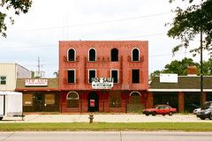
Today, urban explorers, kids who break into abandoned buildings in the Rust Belt, see it before other people do.
That geography is significant for a very important reason. Travelers who left zone of prosperity began to write about both history and the future in ways that challenged the dogmas of liberal progress. In losing their faith, they gained the ability to see around the curve of time. The map of decaying places, in other words, is invaluable to those trying to understand either history or their fate.
Deindustrialization may be the future, after all; it was in Britain's future, and it may well be in America's. A geography of decay becomes the map of fantasies about alternatives to liberalism.
My project, The Memory Machine, recently screened at the annual meeting of the History of Science Society, was filmed at the Detroit Book Depository.
Labels: evanescence, geoparsing, historiography, history, landscape
posted by Jo Guldi at 2:37 PM
![]()
![]()


5 Comments:
New England has its ghost towns as well, though they are now mostly patches of forest with the odd cellar hole or remnants of a mill dam. You have to look hard, even when tipped off by a guide book, to make out the lines of such places. They usually represent farming hamlets on marginal land that became uneconomical as the western lands opened up and agriculture moved in the Ohio Valley.
Recently, I doubted my faith in the capacity of visual/aural communication to inspire intellectual as well as emotional engagement, to avoid common, tired, This American Life and American Experience media tropes and maintain the viewer's attention. The Memory Machine justifies multi-media academic work. Thank you for sharing it in a public forum.
Fascinating. I'm reading this as part of a mobile video class in an MFA program at UTD. On a more personal level I am reminded of experiences I had with a friend of mine many years ago, where we drove through small towns and countryside within 2 hours of Dallas to go through abandoned buildings and houses. Treading the line between trespassing and exploring, saving and stealing, we were looking for places close to collapse, and looking for artifacts that were still in these places, which we were happy to liberate. I have hundreds of slides from these adventures, and took home some pretty cool treasures. What I'm struck by after reading about your work is the impact these places left on me, particularly when I left with piles of old photographs, of people and families I had no knowledge of. Still mulling, and grateful for your post.
Rrrramone, how fascinating! I actually grew up in Dallas (not far from where your seminar meets -- the geographical convergences in this evening's classroom are more subtle than virtual reality suggests), and I've always had a fondness for the old country seats like Hearne and Calvert. I'd *love* to hear what your itinerary was. Do you have links to any of your photos?
The itinerary was completely random, though we did revisit some places more than once. And I just got a slide scanner and haven't started scanning them yet, but I will! :-)
Willie
Post a Comment
<< Home