Maps and Nationalism
We like to think that modernity means the spread of information. Newspapers, maps, travel: all these things supposedly bind peoples into a single national whole. We like to think these things are true; but sometimes such stories are too easy.
In 1775, Boswell had just heard that parts of the East Indies were better mapped than the Scottish Highlands of Britain itself, and he found the fact outrageous. Johnson merely observed, “That a country must be mapped, it must be traveled over.”
Boswell, a Scot, thought he better knew what his English friend was thinking. Don’t you meant to say, he jibed, that "it is not worth mapping?”
In 1784, the modern view of the nation, with its boundaries firmly delineated, the shape of the country itself an icon, was transmuted from the heavy volumes of private libraries consulted by the gentry, into a medium more common, widespread, and accessible. These maps, one assumes, should have brought to an end anxieties like Boswell’s (in 1775) over the position of any particular people, assimilating them all into a single icon of national unity. Sixty years before the arrival of a national press, the visible shape of the nation, in tangible and portable form, offered Britons a ticket for exploration and a tool for identity.
Yet the cheap printed map was also the child of twisted corridors of state dissemination. Republishing the results of military conquest and survey, the cheap printed map indirectly translated the state’s activities for a consuming public. That translation was idiomatic at best.
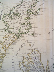
For reasons that hinged upon the history of military mapping and the government’s lead role in distributing geographic data upon which commercial maps depended, the nation depicted in these maps was informed by peculiar distortions. The survey of Scotland performed in the 1750s that became the basis for early nineteenth-century maps was trigonometrically out-of-date; as new surveys of Scotland were delayed by a military more concerned with troubles in Ireland, the outdated data was rejected by cartographers.
Publishers instead routinely depicted Scotland as a white corner on the map, lopped off by the edge of parchment that fell just above Edinburgh. The standard nineteenth-century map of Britain that hung in classrooms excluded most of Scotland from the nation pragmatically defined. Such facts raise the question of what nation, exactly, modern Britons thought they belonged to.

C. Smith, Smith’s Map of England & Wales (London: Printed for C. Smith, 1830). (view full image at the National Library of Australia)
The traditional story of how modern Britons came to understand themselves as members of a nation tells a far more straightforward account of what national implied. Since T. B. Macaulay’s History of England of 1848, official accounts of British identity have tended to emphasize the eighteenth and nineteenth centuries as periods of successful assimilation, in which the fissures of earlier religious and political divides were healed by the salve of commerce, communications, and military exercise. While some scholars interrogate the limits of assimilation, even then, the received narrative tends to take for granted the inclusive work of enlightenment processes like communications and mapping. In fact, mapping itself was a creature of government, like the government-directed military and postal communications that spawned the early surveys upon which commercial cartographers depended. As a result, public maps took on contingencies of intension and empire that worked to structurally exclude Scotland from full integration in the consciousness of ordinary Britons. London publishers complained and Edinburgh cartographers tried to remedy the situation, but neither succeeded. It was the confusion of government practice, rather than English prejudice or Scottish self-assertion, that erased Scotland from the national map.
The map could only direct the traveler as well as allowed by the militarized history of cartographic practice. The common travelers’ aim, unlike the state, was not to police, but rather to plan a route through known and unknown regions, determining the likelihood of trade and the relationship between territories for secure travel and territories of adventure. As students, geologists, and railroads adapted standard maps to their own purposes, the fissures of the nation enshrined in maps were carried over to other practice. The tangible shape of the nation had become a tool of national distortion.
Labels: benedict anderson, britain, cartography, maps, nationalism, nations, scotland, t. b. macaulay, technology
posted by Jo Guldi at 12:18 PM
![]()
![]()


0 Comments:
Post a Comment
<< Home