Landscape organizes everything within sight.

Thursday, November 20, 2008

5-minute digital history experiment: Places Left Behind by Rail


View Larger Map

There I was, dutifully taking notes on Samuel Shaen's Review of Railways and Railway Legislation (1846), and linking up his review of railway statistics to the larger themes in my abstract mind-map of themes important to the history of British railways.

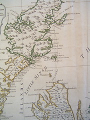
That mind-map, which I've blogged about below, allows me to organize my citations, quotations, and thematic notes under an overlapping series of larger, abstract thoughts, which are helping me make provocative connections early in the research process. One big thought in my mind-map is "The Problem of the Geographical Periphery," which has to do with sectional politics resulting from where the railways go and don't. It's related to other interesting thoughts like "The Power of the Railways to Transform Geography" and "Places Left Behind by Rail." Shaen gives a nice list of the English county towns that still aren't directly hooked up to London in 1846. As you can see, there are a bunch of them.

Since I'm trying to think through where the rails go and don't on the level of geography, it occurred to me that it would be really stellar to have a map.

Here we go, in five-minute experiment form.

I'd never done it before, but I'd heard right. Producing your own map of points (or lines, or points and lines linked to photos and text) is ridiculously easy now. Five minutes, probably less. Here they are, the nine towns in question. I know it's not a miracle, and it doesn't tell you everything you'd want to know about the geographical periphery by a long stretch, but isn't it nice to see them? See how they're all on the west, not the east?

A lot of them are near agricultural districts. Rail immediately served manufacturing, mining, and shipping points. Agricultural centers were left behind, and British agriculture almost immediately started the long slow path into decline.

It gets better. If you zoom in on the map (as I did when I was placing the little pointers), you start to notice that a good number of these towns still retain their eighteenth-century shape: a very small net of streets hugging the main highways. Getting left behind by the rail in 1846 permanently retarded their progress, as rail sped up the differential between industry and places left behind.


View Larger Map

oOo


The plethora of tools like this really come together when a researcher is trying to assemble a series of connections and ideas to present to other scholars.

All of my tools here serve traditional purposes. The mind-map I'm showing you serves a very traditional purpose: the outlining of paragraphs that will comprise the backbone of the chapter on railway and political economy in the 1830s and 40s in the book manuscript I'm preparing. The map above serves, for the moment, as a visual aid to my own imagination; if I can add a bit more data to make sense of why the periphery looks the way it does, that map might become a visual aid to the book itself.

I believe that it's the small tools like these that enhance our skills at visualizing arguments, that make possible small 5-min experiments, where the shape of how digital technology is transforming academic research is mostly clearly visible.

That opens up the room for experiment and risk-taking behavior. Despite my interest in geography, I'm not adept at map-making, and I've shied away from mapping my roads and trains for a long time. The 5-min experiment lowers the threshold for new ways of thinking. It makes it possible for political/social historians like myself to mess around outside of my comfort zone.

If we give grad students and undergrads the room to try this sort of thing, it's this sort of messy sorting of ideas and launching of experiments that could come to characterize humanities pedagogy: start with a small mapping experiment, see if you can identify the patterns at stake, keep mapping and moving until the project takes on its own form.

A characterization of humanities pedagogy based on risk-taking, insight, and pattern-finding is very exciting. It pushes past the monotony of the college essay and re-emphasizes the skills of perception upon which the humanities have traditionally been based. It creates richer minds and broader sets of experience.

I won't press my claims too far, but let me rest with this conclusion: I'm excited about my five-minute experiments and the direction in which they tend.

Thursday, November 13, 2008

Manifesto: Against the Death of the Public Intellectual

The SSCI (Social Science Citation Index) appeared in 1973 and provided the basis for rankings of publications by citation counts – the number of citations that linked to a particular publication. America’s Best Colleges Rankings on US News and World Report began to be published in 1983, and it too compiled statistics on publications, broken by department and university. As quantitative citation became the measure of success, minority professional publications that did the citing were prioritized over mainstream, public journals. The academic’s relevance was defined in terms of his footnoting colleagues, not in terms of an unknown public of New Yorker readers. Through an insistence on the metrics of the superscript, “publish or perish” effectively eliminated appeal to the public as an item of academic concern.

The proliferation of abstruse publications was hastened by one last new trend, electronic publication. Expensive institutional subscriptions funded by university libraries still float the expensive print journals, with little if any profit going to staff and publisher. They were labors of constant cost-cutting. Online publication drove down the cost of publishing, encouraging new journals to spread like the wildfires of Los Angeles. In 1994 the four-year-old Postmodern Culture went electronic, the first peer-reviewed publication to do so. In 1996, First Monday, the child of radical information scientist Edward Valauskas, was launched as an exclusively internet publication. More than half the existent journals on disability arose after 1996, and almost all of these were exclusively published as online journals.

Ironically, electronic publication was initially expected to reinstate the public venue for academics, rather than to abstract journals further from the public realm. The pioneers of electronic journals like First Monday saw electronic publication as an opportunity to liberate discourse from academic constraints, and so reach a broader public. This trend remained particularly true for publications on the study of technology, where an ideologues looked to the internet as a new commons. Yet freedom and publicity were not the trend. Electronic publication soon became another cash cow for the great university presses, which sold packages around the electronic subscription to traditional disciplinary landmarks like Past and Present.

Charging for the electronic version of the publishers’ great mainstays established a precedent for charging for the new ranks of exclusively electronic journals as well, grounding visions of an internet commons. Electronic journals became the private demesne of university publishers who reap between $4 and $200 an article that costs them nothing to buy or to publish. Taylor & Francis, a British publisher, charges between $131 and $2973 for the electronic subscription to a year of quarterlies and monthlies (an individual print subscription is a bargain in comparison, at rates between $42 and $911). Imagine the parent of the disabled child reading across a range of years and journals. The journals and their publishers are not intended highwaymen, of course; they prohibit access knowing that the articles are written by academics, for academics; that university libraries subsidize the fees of their only readers, and that the public cares not a fig for what academic journals have to say in the first place.

Read the rest of my essay, The Surprising Death of the Public Intellectual and a Manifesto for its Restoration, in the latest issue of Absent Magazine.

Monday, November 03, 2008

Twittering from the Chicago Digital Humanities Conference


The Digital Humanities and Computer Science conference is just wrapping up: two days of fairly deep geekery around the programming of text-mining bots, followed by one mind-blowing day of investigations into the use of visualization to discern new forms of cultural change.

From the very small text-search to the very large collaborative overview, these are forces that could revolutionize the practice of history.

My twitter stream from the last three days skims over plenty, but gives a quick overview of some high points, including some of the tools that could be immediately plugged in to any old cultural studies problem on your mind! Offered here for your geeking out pleasure, a quick three days of tweets:

visualized word tree for "i am married" in personals ads: http://tinyurl.com/2brdao about 2 hours ago from twitterrific


"you are like a..." word tree from Jane eyre: http://tinyurl.com/6ekhax about 2 hours ago from twitterrific


mark wattenberg visualizes Richardson's novel Pamela (1740): http://tinyurl.com/676835 about 2 hours ago from twitterrific


hearing about mark wattenberg's big visualizations of culture: for instance, color in the english language http://tinyurl.com/67zrnz about 2 hours ago from twitterrific


live blog of panel that includes paul conway's stuff on distorted photos: http://tinyurl.com/5ee8j7 about 2 hours ago from twitterrific


listening to really disturbing run down of the way that historical photographs are regularly altered for the web -- so much mangled history about 3 hours ago from twitterrific


listening to Scott Branting describe the GIS mapping of an iron-age city in Turkey, speculating about patterns in city form about 4 hours ago from twitterrific


live coverage of #dhcs2008: http://tinyurl.com/6lfr4k 7:46 AM yesterday from twitterrific


#dhcs pasenek sculley presenting "a study of parody" - lit crit meets machine learning! 7:25 AM yesterday from twitterrific


#dhcs possibilities for new kinds of text mining here, but everything I'm hearing about today looks like 5 yrs from big collaborative use 1:18 PM Nov 1st from twitterrific


thick possibilities for new kinds of text mining here, but everything I'm hearing about today looks like 5 yrs from big collaborative use 1:17 PM Nov 1st from twitterrific


meandre promises synthesized, advanced text search... 12:26 PM Nov 1st from twitterrific


presentation about how SEASR aggregates analysis from a dozen different scholarly search tools: http://seasr.org/ 12:16 PM Nov 1st from twitterrific


machine-extrapolated philologic relationships for the whole of the eighteenth century corpus online!!! 11:07 AM Nov 1st from twitterrific


at the Digital Humanities conference at Chicago, geeking out over Philologic: http://philologic.northwestern.edu 11:06 AM Nov 1st from twitterrific

Sunday, November 02, 2008

Psychogeography of the Border: A Short History

In 1700, it was possible to travel across the borders of states without knowing that one had crossed from one region into the next. In 2000, a traveler stopped and searched by customs could hardly avoid the knowledge of nations. Yet the same traveler in Chicago or New York might daily drive past neighborhoods of which he had no knowledge, passing through the invisible boundaries of spaces he had no ability to read.

The dawn of the modern era saw a boom in technologies of navigation, the result of concerted travel from the Grand Tour to continental exploration to travel for the fiscal-military state. Broadly construed, those tools included not merely the cartographic rules for longitude and latitude, but the whole category of the social tools the traveler uses to tell where he is: drawing, hand signs, and printed guidebooks offered techniques for navigating around cultural boundaries, social difference, and government presence.

Equally significant to the tools themselves, however, was the radical hopes for transparency that spatial tools engendered. The cosmopolitan subject was imagined as a traveler, a freemason, for example, whose social connections enabled him to drift from port to port, exchanging information and trading freely no matter where he landed.

The dream of transparent geography began to break down almost as soon as it was launched. The same technologies of navigation created new, invisible frontiers. Watching the masses of tourists and soldiers travel, blinded by disregard for the interior boundaries they crossed, critical travelers described the geographies they themselves saw: islands of routine, colonies of clerks, savannas of mass culture, lakes of ethnic enclaves, each fixed in space, separated from other subgroups by an invisible boundary, across which members of those territories could not see, into which outsiders rarely peeped. The results are well known to urban historians: gentlemen slumming London's ghettos for sex in the 1820s; Dana's Ten Years Before the Mast; and middle-class reformers entering the slums full of ideas. As soon as modern subjects encountered the invisible frontier, they tried to tame it.

What they discovered was an unknown geography in a state of constant flux that defied the now conventional means of navigation. Those places so marked by their invisible boundaries were in fact generated by many of the same modern processes that had shaped so much navigation: new frontiers in circulation, migration, building, representation, affiliation, and the institutionalization of knowledge.

(sketch of a short article in progress)

(thanks, bill rankin, for the atlases!!)